
The Bachelor Degree was based on an analysis from the overall approach to the architectural object of the administrative-territorial unit, Geoagiu, Hunedoara, Romania.
The first step was to observe the opportunities that this unit offers and the weaknesses that this unit confronts with.In the diagnostic, the relations between the neighbor localities and Geoagiu are weak and underexploited. For the strategy I used another romanian administrative-territorial unit, Calimanesti as a target and a reference point,regarding workforce and territorial development. One of the biggest problems was the lack of coherence between the activities of the localities of Geoagiu. The objective was to determine each locality’s main activity, and to develop it in order to have economic efficiency and diversity inside the region and to prevent competition between them.Another internal issues were the dysfunctional infrastructure and the unbalanced environment.
The solutions I adopted are there rehabilitation of the roads and investment in new orchards and hydraulic projects in areas with the highest risk of flooding(Mures river).Also the strategy included the development of the north-south axis(Zlatna-Orastie) and of the west-east axis(Deva-Sebes).
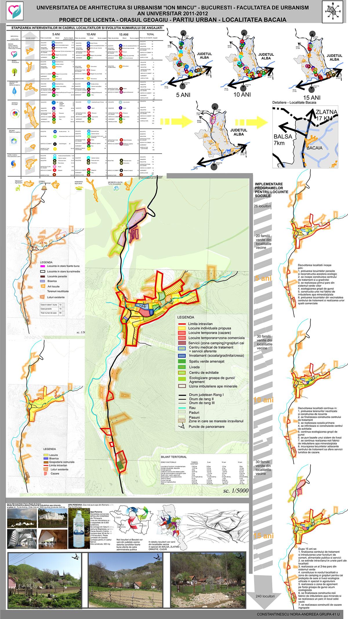
The next step was to choose a locality of Geoagiu, to analyze it in detaila nd to make a proposition of functional zoning. I chose Bacaia, a locality from norther nGeoagiu, situated on the county road DJ 705.It has as main resources thermal and ferruginous water which are used in the treatment of intestinal diseases,rheumatic and hepatobiliary affections,which are not exploited in the present. There is only one mineral water factory that functions only at a local level.It is situated at the foothills of the Metaliferi Mountains at an altitude of 400 meters. The land form is mainly made of hills which represent magnificent landscapes.It has a population of 26 and it has a high risk of depopulation.The locality contains a church and cemetery, a bed and breakfast,30 households, the mineral water factory and agricultural lands.
To develop this locality I used the natural resources mentioned above and I made a medical treatment spa situated in the center of Bacaia. Linked to the medical treatment spa,I developed accommodation units and an educational center. The last consists of a kindergarten and a primary school.Aside the spa I made a horseback riding facility as part of the rheumatic treatment. Also the capacity of the mineral water will increases and the factory itself will have another building.
To achieve this, I chose to implement programs of social housing for the future employees. I estimated that in 5 years time Bacaia will have 20 more households, in 10 years another 30 and in 15 years 20 more. The families will come from the surroundings of Bacaia, the DJ 705 being an important infrastructural element of this development plan.
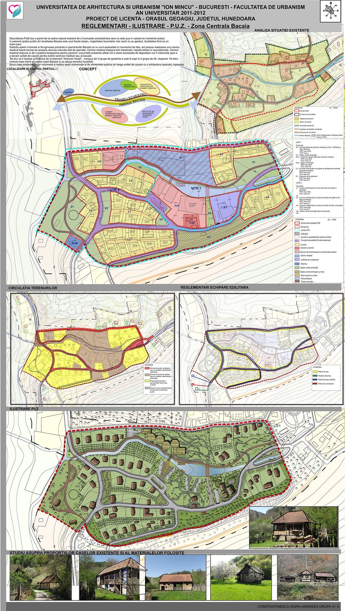
I chose to detail the central zone of Bacaia for the Area Town Planning (PUZ).
The concept of the area town planning started form the existing natural beauty which currently is not highlighted like it deserves. The public space in town in very large, most of the older homes being enclosed.
This freedom of the space I used to highlight the river existed here, Bacaia River which at the present is very small.This river is accompained by equestrian trails used for therapy.Also for the beauty of this trails I porposed orchards for the land behind the houses,by urging the owners.
The whole route begins from the church,the only place in Bacaia where all the locals are get together and follows theriver to the riding center.
The area town planning is formed by two territorial reference units formed by:
UTR 1: S1=the medical treatment spa; V1=landscaped green space; Cs1=accommodation units; Cs2=commercial; L2=individual housing accommodation encouraged to develop touristic activities; E1=educational center
UTR 2: L1=individual housing with orchards in the back of the house; L3=individual housing with orchards in the front and the back of the house; L4=individual housing with orchards in the front of the house; V2=small landscaped green space without any constructions.
I equipped the place with water, sewer,gas and electricity. Also considering the principles of the sustainable development I used local materials (wood, rock, roof tiles), solar panels and thermal water heating.
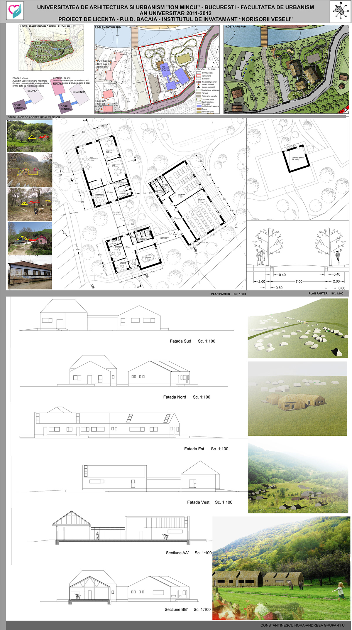
For the last part of the project I had to detail an architectural object from the area town planning studied before. Being part of the central zone of Bacaia, in interdependence with the medical treatment spa, I chose to detail the Educational Center, named “Happy clouds”.
At first for the plot that I chose I had to make a detailed urban plan (PUD - left)containing regulations and the illustration. This educational center is used by the employees of the mineral water factory,medical treatment spa, accommodation units and agriculture.
Surface of the plot= 4050 squere meters
Surface of the constructible = 1000 sm
Surface of the building= 460 sm
The educational center is located near by the river and is formed by a kindergarten and a primary school but having small proportions. The kindergarten functions for two groups of children between 3 and 6 years, formed by 6 children and the primary school also for two groups formed by 25 and 18 pupils. To made this center I studied the proportions of existing houses, coating and materials used in general by the locals. The center was made of concrete frame structure with wood plywood and based stone. The concept was to make a building integrated into the rest of the landscape and to become part of this locality but with an air of modernity.

